Fighting off pests with deep learning and drones

In a new study, researchers tested different deep learning methods to detect the nests made by pine processionary moth larvae on pine and cedar trees.

The nest of a pine processionary moth.

Early detection of pest infestation is an important first step in the adoption of control measures that can be tailored to specific local conditions. Remote sensing technology can be a helpful tool, allowing the quick scanning of large areas, but it’s not universally applicable as sometimes items can be hard to detect. Unmanned aerial vehicles (UAVs), or drones, on the other hand, can help by getting closer to individual trees and detecting smaller atypical signals.

The pine processionary moth is an insect infesting trees in gardens and parks, threatening public health because of the hairs released by its larvae, which can cause a stinging or itching sensation. The pest is rapidly growing in numbers and conquering new territories, which makes it a species of concern.

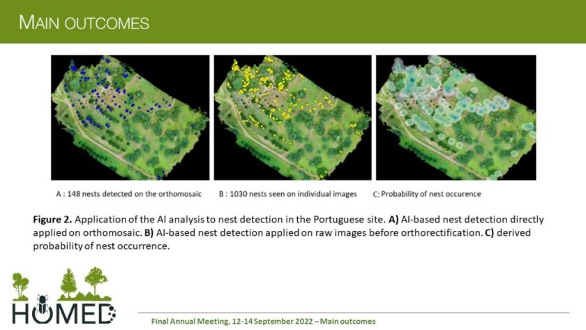
In a new study, researchers tested different deep learning methods to detect the nests made by pine processionary moth larvae on pine and cedar trees. Drones flying over the trees took images, which were then analysed with the help of artificial intelligence (AI) to identify and localise the nests.

Drone images from Portugal.

The use of AI on drone images proved effective to detect pine processing moth nests on trees of different species and sizes, even under variable densities. The method can be successfully used in both forest and urban settings to help detect moth nests. That way, tree health managers can be informed about where the nests are and take appropriate measures to contain the damage and the public health risks.

“The study proved the advantage of using UAVs to document the presence of at least one nest per tree,” the researchers write in their study, which was published in a special issue of the journal NeoBiota dedicated to forest pests in Europe. “It therefore represents a substantial step forward in the integration of the UAV survey with ground observations in the monitoring of the colonies of an important forest defoliating insect in the Mediterranean area.”

Furthermore, they suggest that the method can be extended to other pests.

“This technique can pave new avenues in the surveillance and management of emerging and non-native pests of trees, where early detection and early action should go together to achieve a satisfactory level of protection,” the study authors write in conclusion.

Research article:

Garcia A, Samalens J-C, Grillet A, Soares P, Branco M, van Halder I, Jactel H, Battisti A (2023) Testing early detection of pine processionary moth Thaumetopoea pityocampa nests using UAV-based methods. In: Jactel H, Orazio C, Robinet C, Douma JC, Santini A, Battisti A, Branco M, Seehausen L, Kenis M (Eds) Conceptual and technical innovations to better manage invasions of alien pests and pathogens in forests. NeoBiota 84: 267-279. https://doi.org/10.3897/neobiota.84.95692

Can deep learning help us save mangrove forests?

Object-oriented classification of fused Sentinel images can significantly improve the accuracy of mangrove land use/land cover classification.

Mangrove forests are an essential component of the coastal zones in tropical and subtropical areas, providing a wide range of goods and ecosystem services that play a vital role in ecology. They are also threatened, disappearing, and degraded across the globe.

One way to stimulate effective mangrove conservation and encourage policies for their protection is to carefully assess mangrove habitats and how they change, and identify fragmented areas. But obtaining this kind of information is not always an easy task.

“Since mangrove forests are located in tidal zones and marshy areas, they are hardly accessible,” says Dr. Neda Bihamta Toosi, postdoc at Isfahan University of Technology in Iran working on landscape pattern changes using remote sensing. In a recent study in the journal Nature Conservation, together with a team of authors, she explored ways to classify these fragile ecosystems using machine learning.

Comparing the performance of different combinations of satellite images and classification techniques, the researchers looked at how good each method was at mapping mangrove ecosystems.

“We developed a novel method with a focus on landscape ecology for mapping the spatial disturbance of mangrove ecosystems,” she explains. “The provided disturbance maps facilitate future management and planning activities for mangrove ecosystems in an efficient way, thus supporting the sustainable conservation of these coastal areas.”

The results of the study showed that object-oriented classification of fused Sentinel images can significantly improve the accuracy of mangrove land use/land cover classification.

“Assessing and monitoring the condition of such ecosystems using model-based landscape metrics and principal component analysis techniques is a time- and cost-effective approach. The use of multispectral remote sensing data to generate a detailed land cover map was essential, and freely available Sentinel-2 data will guarantee its continuity in future,” explains Dr. Bihamta Toosi.

The research team hopes this approach can be used to provide information on the trend of changes in land cover that affect the development and management of mangrove ecosystems, supporting better planning and decision-making.

“Our results on the mapping of mangrove ecosystems can contribute to the improvement of management and conservation strategies for these ecosystems impacted by human activities,“ they write in their study.

Research article:

Soffianian AR, Toosi NB, Asgarian A, Regnauld H, Fakheran S, Waser LT (2023) Evaluating resampled and fused Sentinel-2 data and machine-learning algorithms for mangrove mapping in the northern coast of Qeshm island, Iran. Nature Conservation 52: 1-22. https://doi.org/10.3897/natureconservation.52.89639

Artificial neural networks could power up curation of natural history collections

Deep learning techniques manage to differentiate between similar plant families with up to 99 percent accuracy, Smithsonian researchers reveal

Millions, if not billions, of specimens reside in the world’s natural history collections, but most of these have not been carefully studied, or even looked at, in decades. While containing critical data for many scientific endeavors, most objects are quietly sitting in their own little cabinets of curiosity.

Thus, mass digitization of natural history collections has become a major goal at museums around the world. Having brought together numerous biologists, curators, volunteers and citizens scientists, such initiatives have already generated large datasets from these collections and provided unprecedented insight.

Now, a study, recently published in the open access Biodiversity Data Journal, suggests that the latest advances in both digitization and machine learning might together be able to assist museum curators in their efforts to care for and learn from this incredible global resource.

A team of researchers from the Smithsonian Department of BotanyData Science Lab, and Digitization Program Office recently collaborated with NVIDIA to carry out a pilot project using deep learning approaches to dig into digitized herbarium specimens.

Smithsonian researchers classifying digitized herbarium sheets.

Their study is among the first to describe the use of deep learning methods to enhance our understanding of digitized collection samples. It is also the first to demonstrate that a deep convolutional neural network–a computing system modelled after the neuron activity in animal brains that can basically learn on its own–can effectively differentiate between similar plants with an amazing accuracy of nearly 100%.

In the paper, the scientists describe two different neural networks that they trained to perform tasks on the digitized portion (currently 1.2 million specimens) of the United States National Herbarium.

The team first trained a net to automatically recognize herbarium sheets that had been stained with mercury crystals, since mercury was commonly used by some early collectors to protect the plant collections from insect damage. The second net was trained to discriminate between two families of plants that share a strikingly similar superficial appearance.

Sample herbarium specimen image of stained clubmoss
Sample herbarium specimen image of stained clubmoss.

The trained neural nets performed with 90% and 96% accuracy respectively (or 94% and 99% if the most challenging specimens were discarded), confirming that deep learning is a useful and important technology for the future analysis of digitized museum collections.

“The results can be leveraged both to improve curation and unlock new avenues of research,” conclude the scientists.

“This research paper is a wonderful proof of concept. We now know that we can apply machine learning to digitized natural history specimens to solve curatorial and identification problems. The future will be using these tools combined with large shared data sets to test fundamental hypotheses about the evolution and distribution of plants and animals,” says Dr. Laurence J. Dorr, Chair of the Smithsonian Department of Botany.


###

Original source:

Schuettpelz E, Frandsen P, Dikow R, Brown A, Orli S, Peters M, Metallo A, Funk V, Dorr L (2017) Applications of deep convolutional neural networks to digitized natural history collections. Biodiversity Data Journal 5: e21139. https://doi.org/10.3897/BDJ.5.e21139